If you buy through affiliate links, we may earn commissions, which help support our product reviews.
Last Updated Jan 3, 2024
Navigators, adventurers, and sea lovers – lend us your ears!
Have you ever found yourself caught in the vast expanse of the ocean, yearning for a reliable handheld GPS guide to steer you back on course?
Say no more!
We’re here to take you on a journey through the high seas of marine electronics with our Best Handheld Marine GPS Comparative Analysis.
From pinpoint accuracy to robust durability, we’ll explore what separates the good from the truly great.
So strap in, chart a course, and join us as we navigate the digital waves to find your perfect marine companion.
Let the voyage begin!
In a rush? Here are the top 5 handheld GPS devices we cover in this article.
Quick Look: Top 5 Marine GPS Units for Efficient Navigation
| Product Name | Review | Amazon Price | Rating |
|---|---|---|---|
Garmin GPSMAP 79s | Jump to Review | Around $270 Buy Now | 4.3 stars (48 ratings) |
Garmin GPSMAP 86SC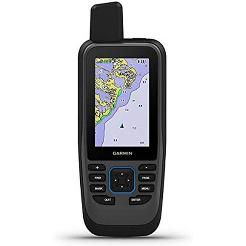 | Jump to Review | Around $400 Buy Now | 4.2 stars (181 ratings) |
Garmin GPSMAP 86i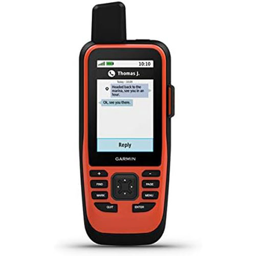 | Jump to Review | Around $511 Buy Now | 4.2 stars (181 ratings) |
Garmin eTrex 32x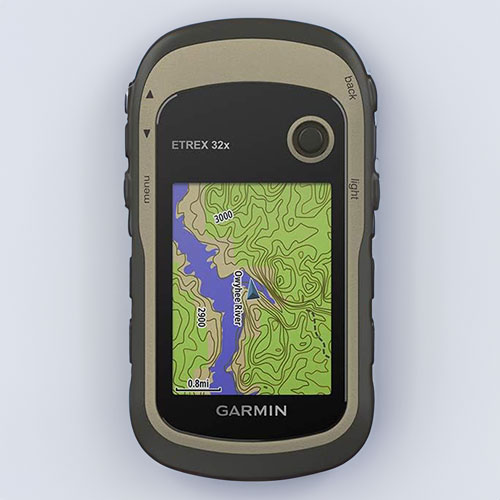 | Jump to Review | Around $250 Buy Now | 4.2 stars (410 ratings) |
Garmin quatix 7X Solar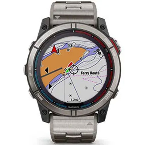 | Jump to Review | Around $1100 Buy Now | 4.6 stars (70 ratings) |
Expert Insights: Why Our Marine GPS Reviews Are Reliable
At Trakkit GPS, we provide our readers with accurate and reliable information regarding GPS tech. This is why we ensure that our experts possess specific vital attributes that contribute to the quality of our reviews:
- Extensive Field Experience: Our experts have amassed years of experience in the field, making them well-versed in understanding the intricacies and nuances of handheld GPS technology, including the best GPS trackers, marine GPS chartplotters, and saltwater fishfinders.
- In-depth Product Knowledge: Our expert reviewers boast an intimate understanding of various tech products, allowing them to analyze each in detail and make experience-based recommendations.
- Rigorous Testing Process: Every product we review undergoes stringent testing to guarantee its performance, durability, and reliability.
- Unbiased Reviews: The reviews we publish are completely unbiased. Our objective is to provide honest evaluations that our readers can trust.
- Customer Feedback: We also consider customer feedback and experiences while reviewing products, giving us a well-rounded view of each product’s performance.
- Commitment to Quality: At the heart of all our endeavors lies an unwavering commitment to excellence. We tirelessly strive to uphold the utmost standards, providing our readers with invaluable, comprehensive, and dependable reviews that empower them to make informed purchasing decisions.
With these principles in mind, let’s explore the core fundamentals of the finest marine GPS handhelds. Following that, we’ll conduct a thorough analysis of the top five options currently on the market.

Decoding Marine GPS: Navigating the Essentials
Marine GPS handheld devices are compact and portable tools designed to assist users in navigating water bodies with precise satellite signals.
These devices operate by receiving signals from a network of satellites, enabling the delivery of accurate and current location information.
Discover more about the functionality of GPS by reading our article on how GPS works.
Marine GPS handheld units go beyond providing location information; they offer a wide range of indispensable features for marine enthusiasts. Some of these features include:
- Electronic Chart Plotting: This functionality allows users to access detailed electronic charts visually representing their current location and surroundings. It proves especially valuable for navigating through unfamiliar waters.
- Waypoint Marking: With this feature, users can mark specific locations and set them as waypoints, simplifying future navigation back to those spots.
- Track Recording: Users can conveniently record their travel routes with this feature, making it easier to retrace their steps if necessary.
- Weather Updates: Many marine GPS handheld units come equipped with weather forecasting capabilities, delivering real-time updates on weather conditions and potential hazards to users.
Given these features, a portable marine GPS is invaluable for boating or fishing excursions. Moreover, advancements in wearable technology mean there are now GPS watches with map displays that offer chart plotting capabilities. Please read our review of the Garmin quatix 7x Solar Below.
Navigational Challenges: Understanding Marine GPS Limitations
Although handheld GPS units offer a wide range of features and benefits, they do come with some limitations that should be considered:
- Screen Size: Due to their compact size, portable marine GPS units often feature smaller screens. Consequently, this can present a challenge when attempting to view intricate maps or charts.
- Battery Life: Another concern is the limited battery life of these units, which is a consequence of their compact design. Heavy usage or extended trips may require extra batteries or access to a power source.
- Accuracy: While portable marine GPS devices are generally accurate, their precision can be influenced by atmospheric conditions, satellite visibility, and obstructions.
Despite their limitations, handheld marine GPS units with maps remain indispensable tools for offshore activity.
Now, let’s delve into the crucial aspects to take into account when buying one.
Essential Features of Marine GPS Units to Look for
When selecting a handheld marine GPS unit, particularly from Garmin devices, several key factors must be considered. These factors include:
Durability and Waterproofing:
When navigating marine environments, your GPS unit will inevitably face harsh conditions, such as saltwater exposure and physical shocks. Therefore, durability becomes crucial in ensuring your device’s longevity.
Additionally, given that water-based activities inherently involve the risk of getting wet, your marine GPS handheld must be waterproof.
This protects the device from potential water damage and guarantees consistent performance, regardless of weather conditions or accidental drops.
Accuracy and Signal Strength:
The primary function of a GPS unit is to provide precise location data. Therefore, it is essential to look for units with high accuracy ratings.
Furthermore, your device’s signal strength is critical as it directly impacts its ability to receive satellite signals in real-time. Integrating a digital compass into the GPS further enhances navigational accuracy.
High Sensitivity GPS Receiver:
When choosing a handheld GPS unit, a critical feature is a high-sensitivity GPS receiver.
This specialized receiver is meticulously designed to capture GPS signals efficiently and effectively, even in the most challenging environments.
Whether navigating through inland lakes, traversing vast oceans, or exploring remote river systems, this advanced technology ensures reliable and accurate positioning.
With minimal signal obstruction, you can have peace of mind knowing that your GPS unit will guide you with precision and confidence on your outdoor adventures on the water.
Battery Life and Power Options:
Battery life is crucial when choosing a handheld GPS device, especially for extended periods on the water. Opting for units with longer-lasting batteries ensures uninterrupted operation and reduces the need for frequent recharging or battery replacement. Some GPS units even feature a USB port for convenient and versatile charging.
Power options are another critical consideration. Specific units can be charged through a standard USB port, AC power, DC power, or solar power. Multiple power options provide added flexibility, mainly when one power source is unavailable.
Furthermore, a USB port for charging and data transfer can be convenient.
Map and Chart Compatibility
Map and chart compatibility is crucial when viewing maps and charts on your GPS unit, especially when navigating unfamiliar waters.
It’s essential to ensure compatibility with electronic marine charts or maps from reputable brands like Navionics or C-MAP.
Some advanced units also offer a worldwide base map for broader navigational contexts.
For a comprehensive guide on the top Marine GPS chartplotters, check out our post here.
Ease of Use and Readability:
Look for a unit with a user-friendly interface, touchscreen control, and convenient access to frequently used features. Additionally, it should provide smart notifications, allowing seamless connectivity with your cell phone on the go.
Furthermore, the display must offer optimal clarity and effortless legibility, even in intense sunlight or dimly lit environments. Consider devices with backlit or LED screens for better visibility.
Additional Info:
For an added layer of safety during your marine activities, consider equipping yourself with one of the best personal locator beacons fitted with GPS capabilities.
These devices offer a means to transmit emergency distress signals and share your precise location with rescue authorities during critical situations.
Garmin’s Elite 5: Unveiling Top Marine GPS Models
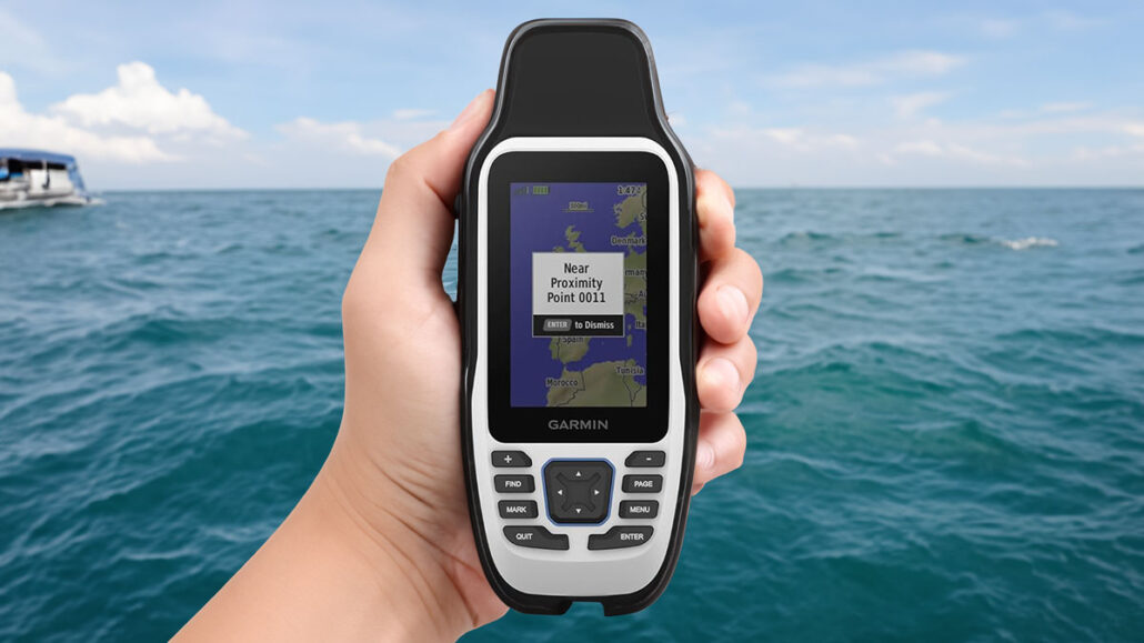
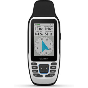
Garmin GPSMAP 79s Handheld Marine GPS/Chartplotter
Price: Around $270
Screen Size: 3 inches
Battery Life: 20 hours
Special Features: Floats, GPS Tracking, Increased memory
Weight: 15.4 ounces
Dimensions: 2.67 x 6.85 x 1.67 inches
Features & First Impressions:
The Garmin 79s sets a high standard for marine GPS devices. Its robust features and user-friendly design offer clear and crisp viewing with its 240 x 400 display resolution.
A key feature includes a floatable design for reassurance if accidentally dropped overboard.
The GPSMAP 79s utilize multiple satellite constellations, including GPS, GLONASS, Beidou, Galileo, QZSS, and SBAS, ensuring accurate and reliable global navigation capabilities.
This device can store and monitor up to 10,000 waypoints, showcasing its exceptional memory capacity.
The built-in 3-axis tilt-compensated electronic compass and barometric altimeter also provide valuable information on heading and pressure changes.
The Garmin 79s is a reliable and versatile tool for marine activities, combining innovative technology with practical design.
Pros
- Floatable design
- Accurate tracking
- Extensive memory capacity
- Built-in compass and barometer altimeter
- Clear, high-resolution display
Cons
- Unhelpful and vague manual
Performance & Overall Experience:
The GPSMAP 79s is a valuable companion for marine adventures. It provides consistent and accurate tracking, even in challenging conditions.
The high-resolution display remains clear under sunlight, and the sturdy construction handles bumps well.
The intuitive interface allows for effortless navigation. Plus, the floatable design adds confidence during water-based activities.
While the manual could be more detailed, the GPSMAP 79s is a reliable and versatile tool for portable marine navigation.
Tested Features:
- Floatable Design
- High-resolution Display
- Accurate Tracking
- Extensive Memory Capacity
- Chart Plotting
Product Details:
| Brand: | Garmin |
| Model Name: | GPSMAP 79s |
| Model Number: | 010-02635-00 |
| Product Dimensions: | 2.67 x 6.85 x 1.67 inches |
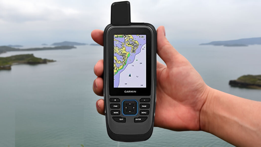
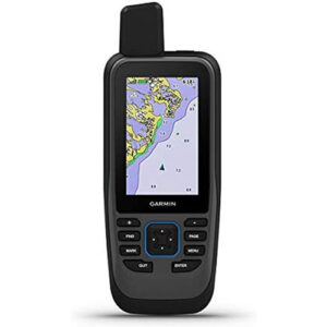
Garmin GPSMAP 86SC, Floating Handheld GPS
Price: Around $400
Screen Size: 3 inches
Battery Life: 50 hours
Special Features: Floats, WiFi connection to Chartplotter
Weight: 9.6 ounces
Dimensions: 1.7 x 2.65 x 7 inches
Features & First Impressions:
The Garmin GPSMAP 86SC offers an impressive array of features. Its floating design ensures the unit stays afloat, reducing the risk of loss during marine activities. The 3-inch display is sunlight-readable, providing precise and detailed visuals even in bright conditions.
With preloaded BlueChart G3 coastal charts, this device combines the best of Garmin and Navionics data to deliver comprehensive and accurate navigation information. Additionally, it can stream boat data from compatible chartplotters, consolidating marine system information for a more effective maritime experience.
From the moment you see it, the device exudes reliability with its robust construction and intuitive button operation, promising a seamless user experience.
Pros
- Water-resistant, floating design
- Sunlight-visible 3″ display
- Preloaded BlueChart G3 charts
- Streams data from chartplotters
- Convenient autopilot remote control function
Cons
- Poorly written product manual
Performance & Overall Experience:
The GPSMAP 86SC delivers accurate, real-time location data even in challenging marine conditions.
Its high-sensitivity receiver ensures strong signal reception for reliable navigation.
Its internal rechargeable lithium battery offers an impressive operational time of up to 50 hours, perfect for extended outings on the water.
Streaming data from compatible chartplotters, the Garmin 86SC provides a consolidated view of marine system information.
Overall, the GPSMAP 86SC is a reliable companion with robust construction, intuitive operation, and various features for marine activities.
Tested Features:
- Garmin Auto Pilot Remote Function
- Chart Plotter Data Streaming
- BlueChart G3 Maps Usage
- Battery Endurance
Product Details:
| Brand: | Garmin |
| Model Name: | GPSMAP 86sc |
| Model Number: | 010-02235-02 |
| Product Dimensions: | 1.7 x 2.65 x 7 inches |
Garmin GPSMAP 86i, Floating Handheld GPS
Price: Around $511
Screen Size: 3 inches
Battery Life: 50 hours
Special Features: Floats, Data Streaming, GPS tracker
Weight: 1.1 pounds
Dimensions: 8.74 x 6.06 x 3.66 inches
Features & First Impressions:
The Garmin GPSMAP 86i is a device meticulously engineered for exceptional performance, boasting many impressive features that set it apart in the fiercely competitive market of handheld maritime GPS units.
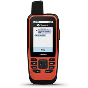
Arguably, the most noteworthy of these features is its InReach capability, which enables seamless two-way text messaging and location sharing through GPS tracking. This remarkable functionality is made possible by subscription-based access to the unparalleled 100% global Iridium satellite network, ensuring uninterrupted communication even in the most remote parts of the ocean.
Our initial impressions of the GPSMAP 86i are overwhelmingly positive. Its InReach capabilities provide an unrivaled level of safety and communication, surpassing many competitors.
Despite its higher price point, its peace of mind and unparalleled connectivity in remote marine settings make it a worthwhile investment.
Pros
- Solid satellite communication
- Two-way text messaging (Interactive SOS)
- Accurate GPS tracking
- Remote autopilot control
- Durable and waterproof
Cons
- Charts require updating pre-use
Performance & Overall Experience:
The GPSMAP 86i excelled in every performance test. With pinpoint GPS accuracy, reliable satellite communication, and seamless autopilot remote control, it proved invaluable during the marine navigation exercises we put it through.
The device maintained a strong signal in remote marine environments, ensuring constant access to vital location and communication data. Its easy-to-use two-way text messaging feature worked flawlessly, providing a lifeline to the outside world when there are no other options.
Impressively, the battery lasted on longer ventures without frequent recharging.
Overall, our highly positive experience with the GPSMAP 86i confirms it to be a robust and reliable tool for marine navigation. Its comprehensive features and superior performance make it a worthwhile investment for maritime enthusiasts.
Tested Features:
- Satellite Communication Reliability
- Two-Way Text Messaging
- GPS Tracking Accuracy
- Garmin Autopilot Remote Control
- Chart Update Process
Product Details:
| Brand: | Garmin |
| Model Name: | GPSMAP 86i |
| Model Number: | 010-02236-00 |
| Product Dimensions: | 8.74 x 6.06 x 3.66 inches |
Garmin eTrex 32x Rugged Handheld GPS Navigator
Price: Around $250
Screen Size: 2.2 inches
Battery Life: 25 hours
Special Features: Topographical maps, inland waterways
Weight: 5 ounces
Dimensions: 4 x 2.1 x 1.3 inches
Features & First Impressions:
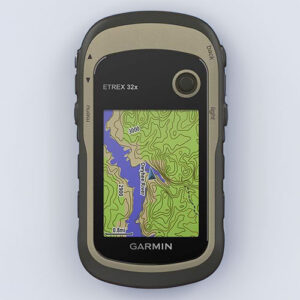
The Garmin eTrex 32x is a rugged handheld GPS navigator that impresses with its compact and lightweight design, perfect for marine adventures.
It covers all inland waterways with preloaded Topo Active maps for accurate navigation.
Despite its small 2.2-inch screen, 240 x 320 pixels resolution ensures clear and readable map visuals.
With support for GPS and GLONASS satellite systems, it offers increased accuracy and reliability.
The device has 8GB internal memory, expandable with a micro SD card, for extensive map downloads.
However, it lacks floating capability and water resistance, making it unsuitable for boaters.
I am impressed by the eTrex 32x, as it combines a compact design with versatile capabilities, making it an excellent companion for maritime activities.
Pros
- Compact and lightweight design
- Preloaded with Topo Active maps
- Supports GPS and GLONASS satellites
- 8GB internal memory, expandable
- Long-lasting battery (25 hours)
Cons
- Does not float
- Only water-resistant, not waterproof
- No detailed marine charts
Performance & Overall Experience:
The Garmin eTrex 32x is a reliable companion for backup marine navigation, delivering solid performance. Its high-sensitivity receiver swiftly captures signals and maintains a consistent connection, ensuring accurate location data during our inland waterway activities.
While the device lacks detailed marine charts, the preloaded Topo Active maps adequately meet our needs, providing helpful information and prominent landmarks.
Although it’s not waterproof, it can withstand light splashes, and careful handling prevents significant water damage.
Despite a few limitations, the Garmin eTrex 32x offers a cost-effective solution for navigating inland and coastal waterways, making it a practical choice.
Tested Features:
- GPS and GLONASS Reception
- Map Download Capacity
- Battery Longevity
- Water-Resistance Level
Product Details:
| Brand: | Garmin |
| Model Name: | eTrex 32x |
| Model Number: | 010-02257-00 |
| Product Dimensions: | 4 x 2.1 x 1.3 inches |
Garmin quatix 7X Solar Watch with GPS/Chartplotter
Price: Around $1,100
Screen Size: 1.4 inches
Battery Life: 28 days
Special Features: Boating, maritime charts
Weight: 3.2 ounces
Dimensions: 2.01 x 2.01 x 0.59 inches
Features & First Impressions:
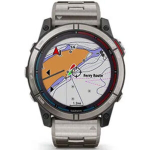
The Garmin quatix 7X Solar Watch is a true marvel of modern technology. It seamlessly combines the convenience of a wearable with the robust features of a marine GPS unit. One of its standout features is the impressive solar charging capability, eliminating the need to worry about battery life during long journeys.
This watch is incredibly durable and purpose-built to withstand even the harshest marine environments. With a remarkable water resistance rating of up to 100 meters and a robust, reliable design, it unquestionably lives up to its reputation as the best solar GPS watch for boating.
Upon first impression, it becomes clear that this watch was meticulously crafted with mariners in mind. It provides precise GPS location, navigation data, and advanced features such as tide changes and anchor drag alerts. These additional functionalities make it an invaluable asset for any water-based activity.
Pros
- Solar charging for extended use
- Robust and durable design
- Water resistance up to 100 meters
- Advanced features for marine use
- Accurate GPS location and navigation data
Cons
- Expensive
Performance & Overall Experience:
The performance of the Garmin quatix 7X Solar Watch exceeded our expectations in all aspects of our testing. The solar charging feature proved dependable and efficient, delivering extended battery life even on overcast days.
Despite its compact screen size, the display remains crystal-clear and effortlessly legible, while the watch itself surprises with its lightweight design and comfortable fit. The GPS and navigation capabilities consistently provide accurate and responsive real-time data for all our marine activities.
In summary, the Garmin quatix 7X Solar Watch is an exceptional choice for those seeking a robust, dependable, and advanced GPS device for boating.
Tested Features:
- Solar charging efficiency
- Durability in marine conditions
- Accuracy of GPS data
- Responsiveness of touchscreen
- Utility of built-in sensors
Product Details:
| Brand: | Garmin |
| Model Name: | quatix® 7X |
| Model Number: | 010-02541-60 |
| Product Dimensions: | 2.01 x 2.01 x 0.59 inches |
Final Charting: Summing it all Up
In conclusion, a handheld GPS unit for maritime activities is an indispensable tool that provides crucial location data and navigational assistance. We have explored the key features to consider when selecting these devices, including durability, waterproofing, accuracy, signal strength, long battery life, map compatibility, and ease of use.
Among the available options, the Garmin GPSMAP 86i stands out as the optimal choice. It boasts remarkable features such as floating capability, data streaming, and an impressive 50-hour battery life, making it the most reliable and robust option for navigating marine environments.
Handheld Marine GPS Commonly Asked Questions
Can you use a handheld GPS on a boat?
Yes, Garmin offers various handheld GPS devices specifically designed for nautical use. These devices have features like marine-friendly design, high-sensitivity receivers for better signal reception, and detailed marine charts. Additionally, they are usually designed to be waterproof or water-resistant and have the ability to float, which makes them ideal for boating and other water-related activities.
How accurate can a handheld GPS be?
GPS devices provide accuracy based on the number of satellites they can connect with. Modern devices often achieve sub-meter accuracy due to multi-constellation availability.
Is a marine handheld GPS worth getting?
A marine GPS handheld is worth investing in, particularly for those engaged in regular or extended maritime activities. These devices are invaluable if your primary means of navigation, such as a boat compass or traditional map, fails. They also provide accurate location data and can be an essential safety tool in emergencies.